Water sustainability in the Tempisque Basin, NW Costa Rica
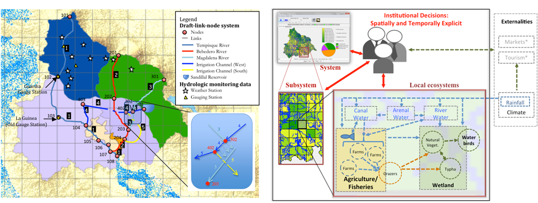
The coupling between the human and natural systems in the Tempisque is mediated by water. The QnD:Tempisque model was built to analyze the behavior of the water system in response to human decisions, and establish the mechanisms by which the water system influences the wetland (Project NSF-CNIC,OISE-1132840). The watershed was modeled as a node-link system where the contributing water of each sub-basin is transported to nodal points that are linked by different routing operations (Fig. 1). This implementation is based on Hromadka et al. (1985) and Muñoz-Carpena and Parsons (2004) components. The different stream routing processes between each pair of nodes are: synthetic unit hydrograph (at 5 minute increments), flow-by structure (i.e. river/canal plus lateral seepage into reservoir), flow-through structure (reservoir), pipe, and channel (Fig. 1). Thus, the model integrates spatial landuse features from its gridded locations into daily summaries of mechanistic water movement at 57 nodes, each with a temporally detailed set of hydrographs, from the highlands to the wetland outlet.

Fig. 1. QnD:Tempisque draft link-node system for the Tempisque Bebedero Watershed (left) and QnD coupling of human and natural components (right)
Impacts of paving the Inter-Oceanic Highway in the tri-national MAP frontier
A study is been conducted to determine the implications of the construction and paving of the Inter-Oceanic Highway in the MAP (Madre de Dios/Peru-Acre/Brazil-Pando/Bolivia) frontier of southwestern Amazon and its effects in land use changes and consequent changes in ecological services. To explore these dynamics, a series of agent-based models considering several different levels of household and landscape complexity are been developed with a multidisciplinary team of social scientists, ecologists and biological engineers. Different model versions are been developed representing different levels of process and network complexity. Process complexity refers to the incorporation of increasingly intricate algorithms, parameters, and feedbacks while network complexity considers the diversity of local agents and their interconnections, markets, land tenure and forest resources. Each model version simulates the temporal and spatial impacts of highway paving on household livelihoods, market connectivity and land tenure along with changes in land use/land cover and concomitant ecological services. As a result, the increase of the complexity within each model version will allow a different and comparative representation of the heterogeneous spatial environment, showing results at local and regional scale, including interactions and mutual feedbacks between human behavior and environmental consequences. Each of these agent model renditions will provide useful insights into complex decision making and adaptive, spatial management amongst local populations, governance agents and the ecological services.

